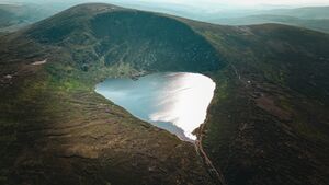
Lough Ouler
Erscheinungsbild
Aus Drone Spots Info
Diese Seite ist eine übersetzte Version der Seite Lough Ouler und die Übersetzung ist zu 100 % abgeschlossen sowie aktuell.
Sprachen:
- Deutsch
- English
| Facts | |
|---|---|
| Country | Irland/en |
| State | — |
| Maps Location | 53° 3' 34.63" N, 6° 22' 25.64" W |
| Max. flight altitude (m) | 120120 m <br /> |
| Map | |
|
Die Karte wird geladen … {"format":"leaflet","minzoom":false,"maxzoom":false,"limit":50,"offset":0,"link":"all","sort":[""],"order":[],"headers":"show","mainlabel":"","intro":"","outro":"","searchlabel":"\u2026 weitere Ergebnisse","default":"","import-annotation":false,"width":"auto","height":"350px","centre":false,"title":"","label":"","icon":"","lines":[],"polygons":[],"circles":[],"rectangles":[],"copycoords":false,"static":false,"zoom":false,"defzoom":14,"layers":["OpenStreetMap"],"image layers":[],"overlays":[],"resizable":false,"fullscreen":false,"scrollwheelzoom":true,"cluster":false,"clustermaxzoom":20,"clusterzoomonclick":true,"clustermaxradius":80,"clusterspiderfy":true,"geojson":"","clicktarget":"","showtitle":true,"hidenamespace":true,"template":"Google Maps Link","userparam":"","activeicon":"","pagelabel":false,"ajaxcoordproperty":"","ajaxquery":"","locations":[{"text":"\u003Cb\u003E\u003Ca href=\"/Lough_Ouler\" title=\"Lough Ouler\"\u003ELough Ouler\u003C/a\u003E\u003C/b\u003E\u003Chr /\u003E\u003Cp\u003EDie maximale Flugh\u00f6he ist hier \u003Cb\u003E120\u0026#160;mm\u003C/b\u003E\n\u003C/p\u003E\n\u003Cp\u003E\u003Ca target=\"_blank\" rel=\"nofollow noreferrer noopener\" class=\"external text\" href=\"https://maps.google.com/?ie=UTF8\u0026amp;ll=53.05962,-6.37379\"\u003EView on Google Maps\u003C/a\u003E\u003C/p\u003E","title":"Lough Ouler","link":"","lat":53.05962000000000244881448452360928058624267578125,"lon":-6.3737899999999996225596987642347812652587890625,"icon":""},{"text":"\u003Cb\u003E\u003Ca href=\"/Lough_Ouler/de\" title=\"Lough Ouler/de\"\u003ELough Ouler\u003C/a\u003E\u003C/b\u003E\u003Chr /\u003E\u003Cp\u003EDie maximale Flugh\u00f6he ist hier \u003Cb\u003E120\u0026#160;mm\u003C/b\u003E\n\u003C/p\u003E\n\u003Cp\u003E\u003Ca target=\"_blank\" rel=\"nofollow noreferrer noopener\" class=\"external text\" href=\"https://maps.google.com/?ie=UTF8\u0026amp;ll=53.05962,-6.37379\"\u003EView on Google Maps\u003C/a\u003E\u003C/p\u003E","title":"Lough Ouler/de","link":"","lat":53.05962000000000244881448452360928058624267578125,"lon":-6.3737899999999996225596987642347812652587890625,"icon":""},{"text":"\u003Cb\u003E\u003Ca href=\"/Lough_Ouler/en\" title=\"Lough Ouler/en\"\u003ELough Ouler\u003C/a\u003E\u003C/b\u003E\u003Chr /\u003E\u003Cp\u003EDie maximale Flugh\u00f6he ist hier \u003Cb\u003E120\u0026#160;mm\u003C/b\u003E\n\u003C/p\u003E\n\u003Cp\u003E\u003Ca target=\"_blank\" rel=\"nofollow noreferrer noopener\" class=\"external text\" href=\"https://maps.google.com/?ie=UTF8\u0026amp;ll=53.05962,-6.37379\"\u003EView on Google Maps\u003C/a\u003E\u003C/p\u003E","title":"Lough Ouler/en","link":"","lat":53.05962000000000244881448452360928058624267578125,"lon":-6.3737899999999996225596987642347812652587890625,"icon":""},{"text":"\u003Cb\u003E\u003Ca href=\"/Datei:Love_Pond.jpeg\" title=\"Datei:Love Pond.jpeg\"\u003ELove Pond.jpeg\u003C/a\u003E\u003C/b\u003E\u003Cp\u003EDie maximale Flugh\u00f6he ist hier \u003Cb\u003E{{{Foaf:Max flight attitude}}}m\u003C/b\u003E\n\u003C/p\u003E\n\u003Cp\u003E\u003Ca target=\"_blank\" rel=\"nofollow noreferrer noopener\" class=\"external text\" href=\"https://maps.google.com/?ie=UTF8\u0026amp;ll=53.05962,-6.37379\"\u003EView on Google Maps\u003C/a\u003E\u003C/p\u003E","title":"Love Pond.jpeg","link":"","lat":53.05962000000000244881448452360928058624267578125,"lon":-6.3737899999999996225596987642347812652587890625,"icon":""}],"imageLayers":[]} |
|

Allgemeine Hinweise
In the middle of the Wicklow Mountains there is this lake that looks like a heart.
Gallery
References
