Apps
Create waypoints
The drone manufacturers do not all offer a function to create waypoints in advance and let the drone automatically fly a route. Only with the Air3 came for the first time a waypoint function. Far more mature but only in combination with the cell phone there are other software solutions. But CAUTION!!! The use of such software can shorten the warranty and cause crashes. Therefore no support from the manufacturers.
- Litchi
- Creating waypoints on PC https://flylitchi.com/hub
- Maven
- Dronelink
Photo Editing
Adobe Lightroom
Probably the most widely used software for quickly improving photos is Adobe Lightroom. With numerous templates, you can quickly get more out of the photo. It also supports DNG (RAW).
Video editing
On the PC
Davinci Resolve

Davinci is a professional solution to edit videos and photos on PC. The free version offers enough tools. The Pro version costs 275 EUR and is aimed at professionals and companies. The program is becoming increasingly popular, making numerous youtube videos available on the subject. Link: Davinici Resolve
Gyroflow
Especially when flying FPV, the videos are very fast and can be shaky. Many drone or action cam manufacturers rely here on the technology RockSteady or Hypersmooth. A software that stabilize the image. The solution is already very good, but it leaves no possibility of fine adjustment. Here the software Gyroflow is used. The software offers very good results to stabilize the image. One should only note that one deactivates the in-house software. This is the only way to generate the necessary image information (gyro data) for Gyroflow.
Mobile
LightCut
LightCut is the official solution from DJI. The app connects directly to the drone to cut the footage. Link: LightCut
Drone Management
Drones collect a lot of data, which can be evaluated sensibly. Be it now to find out if the batteries are still all working or to have a clear logbook.
Airdata
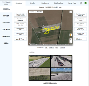
Airdata offers in the free version already very much useful information and supports numerous drones.

The following features are offered: Automatic upload of flight logs: With this feature, you get instant insights into your drone's performance, identify potential issues, and avoid manually collecting flight information. The app is available on Android and iOS and enables detailed analysis of drone data. It also supports maintenance, reporting, notifications and sharing of flight information.
